

Spatial intelligence is the ability to understand a physical or virtual space, and how it changes over time, well enough to reason about the likelihood of outcomes based on specific actions. As AI moves from making decisions and taking actions in business processes to doing so in the physical world, spatial intelligence is what allows it to act autonomously, safely, and effectively.
What is spatial intelligence?
Spatial intelligence is the ability to understand a physical or virtual space, and how it changes over time, well enough to reason about the likelihood of outcomes based on specific actions. It combines four capabilities:
- Perceive a physical space or design a representational space (such as a 3D model).
- Identify the objects within that space and the relationships between them.
- Simulate how changes to an object’s state or activity, and the order of events, alter conditions and outcomes over time.
- Reason about what actions to take to achieve a desired outcome.
People use spatial intelligence every day without thinking about it. Take a driver heading down a residential street.
- Perceive: The driver sees the street and the houses lining it.
- Identify: The driver identifies a child playing with a ball in a driveway.
- Simulate: The driver predicts that if the ball bounces into the street, the child may chase it without looking for cars.
- Reason: The driver slows down and keeps watching the child and the ball so they can stop if the child runs out.
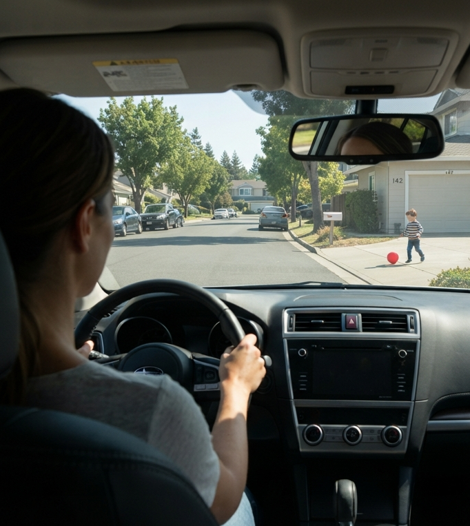
Image 1: Human using spatial intelligence
That’s an example of human spatial intelligence. Hardware and software enable machines to perform the same four capabilities. Take an autonomous vehicle heading down the same street where the child is playing with the ball.
- Perceive: Cameras, LiDAR, and radar capture the street, and sensor fusion merges their readings into one continuously updated model of the surroundings.
- Identify: Computer vision models recognize the child and the ball, then track how far each is from the road and how it is moving.
- Simulate: Prediction models built on physics, probabilities, and patterns learned from data estimate what happens next, including the ball entering the road and the child following it.
- Reason: Safety rules and motion planning choose a response, and vehicle control carries it out: the car slows and keeps tracking the child and the ball so it can stop if the child runs out.
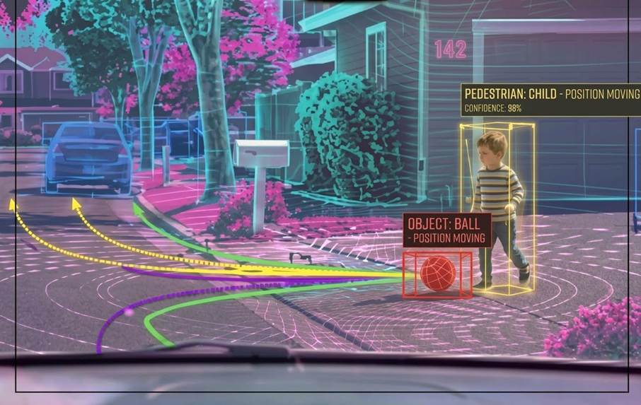
Image 2: Autonomous vehicle using spatial intelligence
Predicting outcomes requires understanding cause and effect, not just patterns. A system that has learned that this street is usually empty at 3 p.m. will be wrong the moment a ball rolls out. Spatial intelligence tracks an object’s state, what it is doing, and the sequence of events, so it can reason that the ball came first and the child may follow.
What are the technologies that enable spatial intelligence in machines?
Machines get spatial intelligence from hardware that senses, computes, and acts, and from software that models spaces, recognizes objects, predicts outcomes, and decides on actions. Each of the four spatial intelligence capabilities draws on both.
| Capability | Hardware | Software |
| Perceive | Cameras, LiDAR, radar, ultrasonic and sonar sensors, motion sensors (IMUs), GPS and indoor positioning (e.g., UWB), 3D scanners, IoT sensors (mounted on vehicles, robots, headsets, drones, and satellites) | Sensor fusion, localization and mapping, 3D reconstruction, geospatial data (GIS), 3D design (CAD, BIM, AI-generated environments) |
| Identify | AI processors in devices and edge systems, including AI built into cameras and sensors | Computer vision, object detection and classification, scene segmentation, tracking, models of how objects relate, vision-language models |
| Simulate | Onboard AI processors for real-time prediction; data-center GPUs and high-performance computing for large-scale simulation | Physics-based, probabilistic, and learned prediction models; physics engines; simulation and digital twin software; world models |
| Reason | Onboard computers and real-time controllers; actuators that carry out decisions (motors, steering, brakes, robot arms) | Rules and safety constraints, motion and path planning, optimization and routing, learned control policies (e.g., reinforcement learning), AI agents, control software |
Note: These lists are representative, not exhaustive. In most machines, the same hardware runs Identify, Simulate, and Reason regardless of the deployment model (edge, cloud, on-premises). Actuators appear under Reason because they enable a machine to complete actions in the physical world. In virtual spaces, the “action” may be a design change or the execution of an operational process.
What are some examples of spatial intelligence use cases across industries and spatial scales?
Spatial intelligence is used across industries and at scales from celestial to molecular. Below are a few examples of the outcomes each use case targets.
| Industry | Use case | Scale |
| Space agencies | Assess the threat from near-Earth asteroids by measuring their size and tracking their paths | Celestial |
| Defense and military | Reduce troop and equipment loss by tracking forces and threats across continents in near real time | Global |
| Insurance | Reduce loss ratios by forecasting severe weather and flood risk to improve policy pricing | Regional |
| Telecom | Lower tower deployment costs by modeling signal coverage across a 3D city to place towers where they work best | City |
| Retail and real estate | More revenue per square foot by predicting how a new store will perform from demographics, foot traffic, and competitor locations | Neighborhood |
| Agriculture | Increase yield and cut fertilizer costs by predicting how parts of a field will respond to varying inputs based on soil, moisture, and crop stress at specific locations | Field |
| Warehousing and logistics | Higher storage density and shorter pick and pack time from testing warehouse layouts virtually before changing the floor | Facility |
| Manufacturing | Throughput gains from designing production lines in 3D to avoid collisions and physical bottlenecks before equipment is installed | Production line |
| Architecture, engineering, and construction | Reduce cost overruns by simulating the impact of design changes before approving field changes, such as having to change the roof support beams when walls move further apart | Structural element |
| Pharmaceuticals | Faster drug discovery from simulating how compounds fit target proteins to rule out unlikely candidates before lab testing | Molecular |
| Gaming | Reduce design time and speed game release by automatically generating a virtual world’s terrain and the paths non-player characters use to move through it | Virtual world |
What kind of value does spatial intelligence deliver?
No single benefit dominated in IDC’s 2025 Power of Place survey. Asked to pick the top 3 benefits of their geospatial investments from 13 categories, 609 respondents in 12 countries most often chose increased productivity and cost savings (27% each). By industry, the leading benefit varied:
- Financial services: respondents most often named improved compliance (31%).
- Manufacturing: cost savings led, at 43%.
- Retail: respondents most often named improved customer experience (31%).
Because the leading benefit varies by industry, build the business case around the benefit your industry values most.
To learn more, read: Using Location and Geospatial Analytics: Prevalence and Benefits of Varied Use Cases.
Conclusion
Spatial intelligence gives AI the ability to understand a space as it changes over time and to reason about the outcomes of its actions, whether the space is a street, a factory floor, a building design, or a molecule. Understanding cause and effect makes predictions and reasoning more likely to hold when conditions change.
The more decisions and actions carry a spatial dimension, the more it costs to misjudge their consequences: underpriced insurance policies and autonomous vehicle collisions, to name a few. Reducing those risks starts with choosing high-value use cases and mapping the capabilities each one requires, then building a deployment roadmap you can execute. IDC can help you navigate each step. Contact IDC to learn more.